© La Plagne

Maps of La Plagne
Download the essential La Plagne maps and plans
Updated
We hope this selection of piste and lift maps, street maps, and activity area maps for La Plagne will help you find your way around so you can make the most of this great part of the world.
La Plagne is made up of six high altitude resorts, and all linked by a free public transport system.
Piste maps
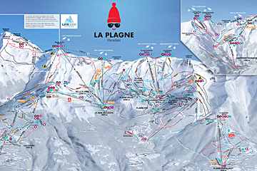
| La Plagne Piste Maps |
|---|
| Paradiski La Plagne - Les Arcs Piste Map |
| Interactive Paradiski Piste Map |
Lifts marked on the piste map using straight black lines are of four types: button tow/drag lift, chairlift, télécabine and télephérique. They have the corresponding abbreviations:
- TK - téléski (drag lift)
- TS - télésiege (chairlift)
- TC - télécabine (gondola)
- TPH - téléphérique (cable car)
Anything prefixed/suffixed with “Express” means a six-person, fast chairlift.
Town maps
| La Plagne Town Maps |
|---|
| La Plagne Aime 2000 Town Map |
| Plagne Centre Town Map |
| Plagne Bellecote Town Map |
| Belle Plagne town map |
| Plagne Villages & Plagne Soleil Town Map |
| Plagne 1800 Town Map |
| Plagne La Roche Town Map |
| Champagny en Vanoise Town Map |
| Montchavin-Les Coches Town Map - Summer | Winter |
| La Plagne Montalbert Town Map - Summer | Winter |
Snowshoeing, winter walking & ski touring maps
Cross-country skiing maps
| La Plagne Cross-Country & Ski Touring Maps |
|---|
| La Plagne Nordic Skiing Trails Map |
| La Plagne Ski Touring Trails Map |
| Montalbert Nordic Skiing Trails Map |
| Montchavin - Les Coches Nordic Skiing Trails Map |
| Champagny Nordic Skiing Trails Map |
Hiking & walking maps
| La Plagne Hiking Maps |
|---|
| La Plagne Hiking & Walking Map |
| Champagny Hiking & Walking Map |
Mountain bike trail maps
| La Plagne Mountain Biking Maps |
|---|
| La Plagne Mountain Bike Trails Map |
| La Plagne Bike Park Map |